The most vulnerable Bulgarian village is not determined only by whether it is close to a river or whether the water stops in the summer. The risk appears where several weaknesses overlap: a small and aging population, limited water sources, a worn-out network and a location in a floodplain, near a torrential ravine or in an area with frequent droughts.
This is also the meaning of the European Commission's warning that “Bulgaria remains vulnerable to increasing climate risks“. The country report states that 9.3% of Bulgarian ecosystems are already affected by severe drought, and losses in the water transmission network exceed 60%. The Commission also notes that Bulgaria still needs to develop drought management plans.
The map of water scarcity passes through small villages
In August 2025, the Minister of Regional Development Ivan Ivanov announced to the parliamentary committee on environment and water that 16 cities and 283 villages were affected by disrupted water supply. The number of affected residents is 260,868. A month earlier, 170 villages in 57 municipalities were on a regime.
Among the most telling examples is Montana. In September 2025, a regime was introduced in Kopilovtsi, Gorna Luka, Mitrovtsi, Zhelezna, Ravna and Gorna Verenitsa. According to the water supply operator, water sources have reduced their flow rate and groundwater has dropped by 4-5 meters. In villages with few inhabitants, this means not just an inconvenience, but dependence on a single water source, a single pumping station and a single pipe.
A similar vulnerability is also seen in Dobrudzha. In July 2025, residents of several villages in the Dobrich municipality protested over a systematic lack of water, with the village of Svoboda reporting ten days without water supply. In the border part of Yambol region, nearly 430 residents of six villages in the municipalities of Elhovo and Bolyarovo were affected by reduced flow or drying up of a water source.
Where drought meets flood
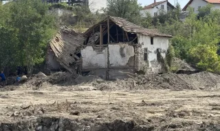
The paradox is that the same village can be threatened by both drought and water. In the summer, low flow rates leave wells and catchments without enough water. However, during a short, intense rain, the dried-up ravine turns into a rapid runoff, and the soil, compacted by drought or devoid of vegetation, absorbs less water.
Therefore, villages in river valleys and low plains are most at risk, especially when their water supply depends on small local sources. The flood risk management plans for the period 2022-2027 divide the country into four basin regions and contain maps of floodplains under different scenarios. However, they do not provide a ready-made ranking in which demographic risk, lack of water and the danger of flooding are combined into a single indicator.
The smallest settlements have the smallest reserve
The demographic picture makes the problem more severe. According to the National Statistical Institute, at the end of 2025, Bulgaria had 4,999 villages, 192 settlements were uninhabited, and 1,280 villages and other settlements had between 1 and 49 people living there. In such an environment, the emergency team, the water carrier, or the restoration of a broken road often have to cover a large area for very few people.
That is why the future vulnerability map should not only show where water can flood houses. It should combine the population, age structure, time to access medical care, the number and reliability of water sources, losses in the network, and the location of the village in relation to rivers and ravines.
Without such an overlay, drought will continue to be measured by the number of villages per regime, and floods — by the damage caused after the disaster. For people in small settlements, the risk begins earlier: when the only well goes down, when the pipe breaks down, or when there is no one to warn in time.
Sources: BTA