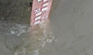
On April 15, 2006, the level of the Danube River near Nikopol rose by 17 cm and reached 857 cm, which is 77 cm above the critical level for the city. 40 public, residential and industrial buildings in the lower part of the city are under water.
This is recalled by BTA.
The spring high water levels of the Danube are known to the locals as “cherry waters”. This is the season of flowering of fruit trees, but also of melting snow and increasing the water flow of the river and its tributaries. This is the time when the Danube becomes an element that can cause a lot of damage. 2006 is characterized by such high water levels that have not been seen for decades.
On Easter (April 23), the level of the Danube at Lom reaches a record in the history of measurements in the Bulgarian section of the river, 985 cm. The river level at Vidin during the spring high waters of 2006 is 965 cm, at Novo Selo - 917 cm. The high Danube wave is over nine meters and near Ruse. The river level near Silistra is 851 cm. The southern industrial zone in Vidin and part of the villages of Botevo and Simeonovo are also flooded, as are port structures in Ruse. Under the water is the remarkable riverside area with the monument to the detachment of Stefan Karadzha and Hadji Dimitar in the municipality of Tsenovo. The National Crisis Headquarters introduces 24-hour duty due to the danger of floods in the municipalities along the Danube River.
The water levels of the Danube and the released water quantities that passed through the riverbed in 2006 have not been observed for 160 years, according to Associate Professor Dr. Stefan Modev, Deputy Dean of the Faculty of Hydrotechnical Engineering at the University of Architecture, Civil Engineering and Geodesy. This situation is naturally determined by the middle and upper Danube and is due to the accumulation of rapid snowmelt from the Carpathians and the Alps with added precipitation in Central Europe.